 www.geodatenkatalog.de (S2L)
Keyword
flach lagerndes Salz
4 record(s)
Provided by
Type of resources
Available actions
Topics
Keywords
Contact for the resource
Service types
-
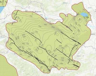
Which salt formations are suitable for storing hydrogen or compressed air? In the InSpEE-DS research project, scientists developed requirements and criteria for the assessment of suitable sites even if their exploration is still at an early stage and there is little knowledge of the salinaries’ structures. Scientists at DEEP.KBB GmbH in Hanover, worked together with their project partners at BGR and the Leibniz University Hanover, Institute for Geotechnics, to develop the planning basis for the site selection and for the construction of storage caverns in flat layered salt and multiple or double saliniferous formations. Such caverns could store renewable energy in the form of hydrogen or compressed air. While the previous project InSpEE was limited to salt formations of great thickness in Northern Germany, salt horizons of different ages have now been examined all over Germany. To estimate the potential, depth contour maps of the top and the base as well as thickness maps of the respective stratigraphic units were developed. Due to the present INSPIRE geological data model, it was necessary, in contrast to the original dataset, to classify the boundary lines of the potential storage areas in the Zechstein base and thickness layers, whereby the classification of these lines was taken from the top Zechstein layer. Consequently, the boundary element Depth criterion 2000 m (Teufe-Kriterium 2000 m) corresponds on each level to the 2000 m depth of Top Zechstein. However, the boundary of national borders and the boundary of the data basis could not be implemented in the data model and are therefore not included in the dataset. Information on compressed air and hydrogen storage potential is given for the identified areas and for the individual federal states. According to the Data Specification on Geology (D2.8.II.4_v3.0) the content of InSpEE-DS (INSPIRE) is stored in 18 INSPIRE-compliant GML files: InSpEE_DS_GeologicUnit_Isopachs_Zechstein.gml contains the Zechstein isopachs. InSpEE_DS_GeologicUnit_Isobaths_Top_Zechstein.gml and InSpEE_DS_GeologicUnit_Isobaths_Basis_Zechstein.gml contain the isobaths of the top and basis of Zechstein. The three files InSpEE_DS_GeologicStructure_ThicknessMap_Zechstein, InSpEE_DS_GeologicStructure_Top_Zechstein and InSpEE_DS_GeologicStructure_Basis_Zechstein represent the faults of the Zechstein body as well as at the top and at the basis of the Zechstein body. InSpEE_DS_GeologicUnit_Boundary_element_Potential_areas_Zechstein.gml contains the boundary elments of the potential areas at the top and the basis of Zechstein as well as of the Zechstein body. The three files InSpEE_DS_GeologicUnit_Uncertainty_areas_ThicknessMap_Zechstein.gml, InSpEE_DS_GeologicUnit_Uncertainty_areas_Top_Zechstein.gml, InSpEE_DS_GeologicUnit_Uncertainty_areas_Basis_Zechstein.gml represent the uncertainty areas of the Zechstein body as well as at the top and at the basis of the Zechstein body. InSpEE_DS_GeologicUnit_Potentially_usable_storage_areas_Storage_potential_in_the_federal_states.gml comprises the areas with storage potential for renewable energy in the form of hydrogen and compressed air. The six files InSpEE_DS_GeologicUnit_Salt_distribution_in_Germany_Malm.gml, InSpEE_DS_GeologicUnit_Salt_distribution_in_Germany_Keuper.gml, InSpEE_DS_GeologicUnit_Salt_distribution_in_Germany_Muschelkalk.gml, InSpEE_DS_GeologicUnit_Salt_distribution_in_Germany_Roet.gml, InSpEE_DS_GeologicUnit_Salt_distribution_in_Germany_Zechstein.gml and InSpEE_DS_GeologicUnit_Salt_distribution_in_Germany_Rotliegend.gml represent the salt distribution of the respective stratigraphic unit. InSpEE_DS_GeologicUnit_General_salt_distribution.gml represents the general salt distribution in Germany. This geographic information is product of a BMWi-funded research project "InSpEE-DS" running from the year 2015 to 2019. The acronym stands for "Information system salt: planning basis, selection criteria and estimation of the potential for the construction of salt caverns for the storage of renewable energies (hydrogen and compressed air) - double saline and flat salt layers".
-
Which salt formations are suitable for storing hydrogen or compressed air? In the InSpEE-DS research project, scientists developed requirements and criteria for the assessment of suitable sites even if their exploration is still at an early stage and there is little knowledge of the salinaries’ structures. Scientists at DEEP.KBB GmbH in Hanover, worked together with their project partners at the Federal Institute for Geosciences and Natural Resources and the Leibniz University Hanover, Institute for Geotechnics Hanover, to develop the planning basis for the site selection and for the construction of storage caverns in flat layered salt and multiple or double saliniferous formations. Such caverns could store renewable energy in the form of hydrogen or compressed air. While the previous project InSpEE was limited to salt formations of great thickness in Northern Germany, salt horizons of different ages have now been examined all over Germany. To estimate the potential, depth contour maps of the top and the base as well as thickness maps of the respective stratigraphic units and reference profiles were developed. The information on compressed air and hydrogen storage potential in the federal states is linked to the identified areas with usable potential in the Layer Storage potential in the federal states (Speicherpotenzial in den Bundesländern). Via the getFeatureInfo request, the user obtains additional information on the different geometries. This enables access to the criteria catalog data sheet in the layer Potential storage areas for flat layered salt (Potenzielle Speichergebiete flach lagernde Salze) of each stratigraphic unit and to the illustrations of borehole profiles and borehole correlations in the layers Boreholes (Bohrungen) and Borehole correlations (Bohrungskorrelationen). Spatial selection and data queries are possible for the following data sets: Boreholes (Bohrungen), Borehole correlations (Bohrungskorrelationen), Isobath (Isobathen), Isopach (Isopachen), Boundary elements of the potential areas Top Zechstein (Begrenzungselemente der Potenzialgebiete Top Zechstein), Storage potential in the federal states (Speicherpotenzial in den Bundesändern) and potential storage areas in the flat layered Zechstein salt (Potenzielle Speichergebiete flach lagernde Zechsteinsalze). The scale of display is limited to a minimum of 1:300.000. This geographic information is product of a BMWi-funded research project "InSpEE-DS" running from the year 2015 to 2019. The acronym stands for "Information system salt: planning basis, selection criteria and estimation of the potential for the construction of salt caverns for the storage of renewable energies (hydrogen and compressed air) - double saline and flat salt layers".
-
Which salt formations are suitable for storing hydrogen or compressed air? In the InSpEE-DS research project, scientists developed requirements and criteria for the assessment of suitable sites even if their exploration is still at an early stage and there is little knowledge of the salinaries’ structures. Scientists at DEEP.KBB GmbH in Hanover, worked together with their project partners at the Federal Institute for Geosciences and Natural Resources and the Leibniz University Hanover, Institute for Geotechnics Hanover, to develop the planning basis for the site selection and for the construction of storage caverns in flat layered salt and multiple or double saliniferous formations. Such caverns could store renewable energy in the form of hydrogen or compressed air. While the previous project InSpEE was limited to salt formations of great thickness in Northern Germany, salt horizons of different ages have now been examined all over Germany. To estimate the potential, depth contour maps of the top and the base as well as thickness maps of the respective stratigraphic units and reference profiles were developed. Information on compressed air and hydrogen storage potential were given for the identified areas and for the individual federal states. The web service "Information system for flat layered salt" gives access to this data. The scale of display is limited to a minimum of 1:300.000. This geographic information is product of a BMWi-funded research project "InSpEE-DS" running from the year 2015 to 2019. The acronym stands for "Information system salt: planning basis, selection criteria and estimation of the potential for the construction of salt caverns for the storage of renewable energies (hydrogen and compressed air) - double saline and flat salt layers".